Scientists publish detailed map of Eastern Tatarstan for precision drilling
Researchers from the Department of Geophysics and GIS, commissioned by local oil powerhouse Tatneft, developed a high-precision geomagnetic model of the eastern part of the Republic of Tatarstan. It has been tested and is already being used for oil drilling.
The magnetic field is generated by the Earth’s core and magnetized rocks in the crust. There are global magnetic field models. Each is a mathematical description of the planet’s magnetic field in its undisturbed state. According to Senior Lecturer Bulat Nasyrtdinov, these models are very inaccurate and unsuitable for drilling operations.
“We created a high-precision digital geomagnetic field model for the area where Tatneft operates. It covers an area bounded by the cities of Nurlat and Bavly to the south, Mamadysh and Yelabuga to the north, Neftekamsk and Oktyabrsky located near its eastern border, and Nizhnekamsk and Chistopol near its western border,” he explained.
The research was conducted as part of a contractual project titled Updating the Magnetic Declination Calculation Software and the High-Resolution Digital Sector Geomagnetic Model of PJSC Tatneft Operations Area.
Bulat Nasyrtdinov explained why the 3D magnetic field model created by KFU geophysicists, which takes into account how its parameters will change from the surface to a depth of 5 kilometers, is so important for oil producers.
“Well trajectory can be controlled during drilling based solely on magnetic field parameters. Knowing how the declination, inclination, and full magnetic field induction vector change in a specific area allows us to determine the exact location of the drilling tool underground,” he elaborated. “It’s especially difficult to correctly drill a horizontal wellbore in an oil reservoir. The oil-bearing formation can be only a few meters thick, and the drilling rig weighs dozens of tons, making it very difficult to maneuver. Horizontal drilling requires a large penetration along the formation, meaning it needs to be entered very smoothly and navigated very carefully, extracting as much oil as possible. We can’t lower a video camera to a depth of 1.5-2 kilometers to see what’s happening in real time: firstly, visibility is poor there, and secondly, such equipment wouldn’t work for long in high temperature and high pressure conditions.”
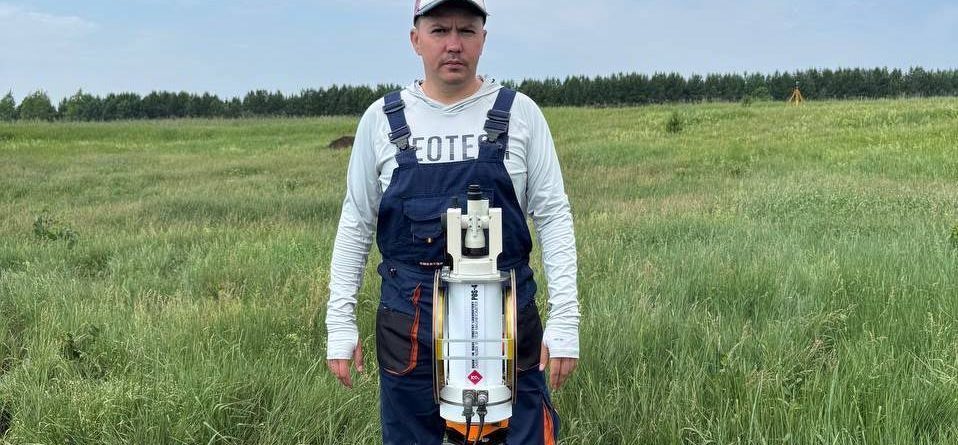
Scientists were able to construct a highly accurate model of the local magnetic field using data obtained with a unique magnetometer.
“Our POS-4 Overhauser scalar-vector magnetometer was custom-made at the Ural Federal University’s Quantum Magnetometry Laboratory. It differs from all those available in our country in that it is complemented by a non-magnetic theodolite. The device measures three components: the induction of the Earth’s magnetic field, as well as its vertical and horizontal components. To accurately estimate other magnetic field parameters, such as declination and inclination, we needed a built-in non-magnetic theodolite,” the scientist continued.
Magnetic declination is the angle between the directions of the magnetic and geographic meridians. Magnetic inclination is the angle between the direction of the Earth’s magnetic field strength at a given point and the horizontal plane.
“The geographic and magnetic poles do not coincide,” he emphasized. “Many people think that the north magnetic pole is located close to us, but in fact, the south pole is moving, and very quickly. From 1900 to 2000, the pole traveled the same distance as from 2000 to 2025. Because the magnetic pole shifts, all parameters of the Earth’s magnetic field also change. For hydrocarbon extraction, it is important to know how these parameters are changing.”
As the model is used, adjustments will be made based on magnetic field data, including from the Kazan University Magnetic Observatory, the oldest in Europe.
“In recent years, solar activity has increased significantly. Solar flares cause magnetic storms—disturbances in the Earth’s magnetic field. We plan to develop a unique program that will help us predict upcoming magnetic storms. It’s best not to conduct drilling operations during these times,” concluded Nasyrtdinov.